Notes from discussion with Ray 6/9/2015
Bronson Canyon also had a horse stable! It was accessed through Canyon Drive about a mile north of the Canyon Drive entrance closer to the quarry. There was a large house there too that Mr. Lawson lived in . There was another structure used as a canteen. These spaces were operated by the Los Angeles Pacific ? who also ran the quarry. Sherman was involved with Clark, Huntington, Chandler and they all owned a piece of the Tejion ranch. After 1947 everything was torn down.
Dear Jean,
I’ve attached some notes I made back in 1982 about Hollywoodland pre-history. These were written on a program called Wordwriter and have not been migrated to present day technology. I probably have the originals on a CD somewhere but am not about to look for them. The print-out came from the “Hollywoodland” folder.
I’ve also attached three scans from the original Engineering Services Company tract map of 1923. This is obviously a well folded map which someone attempted to repair using Scotch brand tape which is unfortunate. The original suffers the ravages of time and high acid paper. I don’t know if these are of any interest but I sent them along anyway. I’m assuming this is the area of conflict. I don’t fully understand what this is all about. The maps are all scanned with north being the top and 1, 2, 3 being top to bottom. If needed I can scan the rest of the map.
I’ve also attached a copy of the Balloon Route logo which I scanned from a photograph of a box car back in 1982. I first started using a computer (IBM 360-91) for personal projects back in 1973 which predates both Steven Jobs and Bill Gates.
I doubt that any film of the construction of Bud Wolf’s castle survives today given that it was photographed on nitrate stock. The film I have is a silent Oater shot in upper Weir Canyon starring Patricia Palmer which has been copied to digital.
I hope this is of some help to Christine.
Christine,
Here is a photo taken looking northeast toward the activity around the “loading bins” on the map. The quarry entrance is at the top of the hill on the right. The tipple was more or less intact until city ownership. As a kid, many the time I slide down its steel face.
I’ve also enclosed a tract map of the railway around Franklin and Bronson. As you can see the railway was on right-of-way midway between Bronson & Tamarind. Although the railway has been gone for 97 years, there is some evidence of that to this day.
I went through my files and have no records of the conditions, covenants or stipulations of the conveyance of residual portions of the parcel to the City of Los Angeles.
I’ve also attached a j-peg of what the folks at the top of Wonderland Drive did to cut down on visitors who wanted to park and gawk at their city view. Wonderland at that altitude is one lane.
Take care………..Ray
Hello Christine,
I’ve attached the logo of Sherman’s Los Angeles Pacific Company which was the local transportation system on the west side of Los Angeles prior to September 1911. I remember residents of the canyon referring to the trolleys as the “Balloon Route” even as late as 1940.
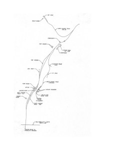
I’ve also attached a map of the tracks inside Brush/Bronson Canyon. The point identified as Hollywood City limits is today the park gate on Canyon Drive. That line also represents the Hollywoodland gates and also the front (south side) of Bud Wolf’s castle. The tracks were ripped out after discontinuance of the trolley on Canyon Drive in 1918.
The building identified as commissary was the barn where we kept our horses. We had a corral on the south side of that structure. The girls camp is today located on the site of the Molar house.
Take care…………Ray
