WHAT IS THIS MAP?

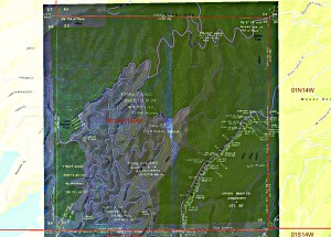
This image shows the original Sherman Hollywoodland Tract era 1923 overlaid on the 2014 City’s Map and Guide to Griffith Park.
The orange outline show the Hollywoodland tract, open space and residential.
The gray color indicates the residential area of the Hollywoodland tract.
The green shading surrounding the Hollywoodland residential area shows the open space Sherman gift of 444 acres.
Note the Lake Hollywood Park’s location inside the HGP area. Should we consider renaming it the Sherman Park?
A few points of interest: the official opening into our HGP area is Canyon Drive. That opening is the same meridian line as the historic stone gates at the entrance of the residential portion of Hollywoodland as well as the end of the southwestern edge of the tract at Durand Drive.
NOTE: The City’s meridian line is incorrectly shown.
